Find your neighborhood in METRO's definitions below (we added the links to plain english definitions) -- then look up METRO's target density on the right |
Metro Density Recommendations |
|||
| 3.07.1303.07.130 Design Type Boundaries Requirement
For each of the following 2040 Growth Concept design types, city and county comprehensive plans shall be amended to include the boundaries of each area, determined by the city or county consistent with the general locations shown on the 2040 Growth Concept Map: Central City --Downtown Portland is the Central City which serves as the major regional center, an employment and cultural center for the metropolitan area. Regional Centers --Nine regional centers will become the focus of compact development, redevelopment and high-quality transit service and multimodal street networks. Station Communities --Nodes of development centered approximately one-half mile around a light rail or high capacity transit station that feature a high-quality pedestrian environment. Town Centers --Local retail and services will be provided in town centers with compact development and transit service. Main Streets --Neighborhoods will be served by main streets with retail and service developments served by transit. Corridors --Along good quality transit lines, corridors feature a high-quality pedestrian environment, convenient access to transit, and somewhat higher than current densities. Employment Areas --Various types of employment and some residential development are encouraged in employment areas with limited commercial uses. Industrial Areas -Industrial area are set aside primarily for industrial activities with limited supporting uses. Inner Neighborhoods --Residential areas accessible to jobs and neighborhood businesses with smaller lot sizes are inner neighborhoods. Outer Neighborhoods --Residential neighborhoods farther away from large employment centers with larger lot sizes and lower densities are outer neighborhoods. (Ordinance No. 97-715B, Sec. 1.) |
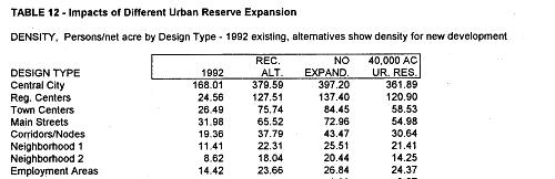
3.07.170 Design Type Density Recommendations
A. For the area of each of the 2040 Growth Concept design types, the following
average densities for housing and employment are recommended to cities
and counties: (Ordinance No. 97-715B, Sec. 1.)
Metro codes from the Metro code at http://www.multnomah.lib.or.us/metro/glance/metcode/metcode307.pdf |